PPL Knowledge - Navigational Systems
Introduction
Aviation is all about safety - and safety is achieved in large part through redundancy. This can be seen in navigational techniques, particularly in VFR flight. Students are taught not to rely solely on one form of navigation, dead reckoning only or VOR navigation only, for example. Instead, several navigation systems and techniques should be used together to support each other. This video here tells you everything you need to know, but here are the important bits written down.A History of Navigation Systems
In the early days, pilots relied solely on maps and what they could see on the ground to navigate. They avoided flying at night and in bad weather. The US postal service initiated the first regular round-the-year scheduled plane service in the world, beginning with the New York - Philadelphia - Washington D.C. route. Bad weather played a large part in making the service notoriously unreliable and even deadly in its early days. Pilots flew "by the rail", meaning they navigated by following the railway tracks.
As the post office tried to expand its air service, pilots began flying at night, and fellow pilots, mechanics, and even sometimes civilians lit bonfires or switched on car lights to point them in the direction of the airfields. The post office caught on to the idea and eventually installed lighted beacons across the whole of its transcontinental mail route, guiding pilots at night.
Navigational aids such as NDBs and VORs, still widely in use today, make use of radio waves to guide planes to their destinations. Today, the aviation industry is moving towards GPS, with radio-based navigation used as a back-up.
Radio Waves Physics Crash Course
- Radio waves are a certain type of electromagnetic (EM) wave
- All EM waves travel at the speed of light; what differentiates them are wavelength and frequency
- (speed of light = frequency x wavelength)
- Generally, the higher the frequency, the higher the higher the penetrating power, and the straighter it travels. X-rays and gamma rays are at the highest frequency end of the EM spectrum and this is why they are able to penetrate the human body, allowing X-ray images and causing cancer
- Lower frequency EM waves are more able to refract and be reflected off objects, which is important in understanding radio-based navigational aids
Non Directional Beacon (NDB)

The morse code identifier is also provided. If the receiver is receiving signal from a working NDB, it will play a tone in morse code, which should correspond to that on the sectional chart. This is one way of confirming that a signal is received, and that the NDB station is working properly.
- Growing obsolete but still used in many parts of the world
- How it works
- NDB station sends out an EM signal in all directions
- In the plane there are two antennas - loop antenna and sense antenna
- The loop antenna is a loop. By Faraday's Law, a current will be induced in the loop at every direction except for when the loop is directly perpendicular to the received signal
- By using two loops set at different angles, the receiver can determine the line along which the signal travels from the NDB
- However, this means that the NDB can be in two possible locations. For example, if the loop antenna senses that the NDB signal is traveling in the line parallel to 180°, the station could either be 180° or 360° relative to the aircraft
- To narrow it down to only one possibility, the sense antenna is used
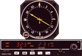
- The equipment used to read NDB signals is known as the Automatic Direction Finder (ADF)
- The ADF needle points towards the selected NDB station
- In some ADFs, the card behind the needle (the one with all the headings) can be rotated, in others they cannot.
- Assuming the ADF card cannot be moved, the ADF will give you the relative heading of the NDB station
- To calculate the bearing of the NDB station from the airplane, you have to manually add the relative heading to your current magnetic heading. For example, if you are flying at 50°, and the ADF reads 20°, the station is 70° relative to your location. Similarly, if the ADF reads 340°, the station is 30° relative to your location.
- If the ADF card can be moved, rotate the ADF card to your current magnetic heading, and the reading on the ADF will already give you the relative heading to the station. This reduces the mental workload of the pilot somewhat.
- Navigating using NDBs
- To fly towards a certain NDB station with calm winds, simply point the aircraft such that the needle shows 0° relative bearing.
- This is known as homing.
- Because the aircraft will be constantly pushed off track, constant adjustments will be made towards the NDB
- This results in a curved track towards the NDB station, which is less efficient.
- Instead, pilots should track towards the NDB
- Apply the wind correction angle.
- The relative bearing would not actually be 0°, but a value equal to the wind correction angle.
- The pilot will know if the suitable correction for wind has been factored in if the relative bearing does not change.
- To track from the NDB, pick a particular heading you would like to fly from the station, and fly the heading, adjusting the track of the aircraft such that the ADF points directly behind the plane, or slightly to the left or right as per the wind correction angle.
- To find the estimated time to the NDB station, turn the aircraft such that the relative angle is 90° (or 270°)
- Formula: time to station in minutes = (time in seconds / change in relative heading in degrees).
- For example, if the relative bearing increases from 90° to 100° in 10 seconds, the time to station = 10/10 = 1 minute.
- Using the ground speed of the aircraft, the pilot will also be able to calculate the distance from the station
- Advantages of using NDBs
- NDBs operate on a lower frequency within the radio-wave spectrum as compared to VORs. Because of this, NDB radio waves are able to follow the curvature of the earth, and can bend around terrain such as hills. This means that pilots can pick up the NDB signals even if there is direct line of sight between the plane and the station.
- Because ADF needle always points towards the station, it is a lot easier to visualize where the station is as compared to VOR navigation.
- Disadvantages are largely due to the nature of the lower-frequency NDB radio waves
- Easily affected by weather, especially thunderstorms / electrical storms
- The ADF needle will deflect momentarily towards lightning when a flash occurs
- Night effect
- At night the ionosphere is more refractive and may cause NDB radio waves to refract off the ionosphere and back towards the plane
- Mountains
- Lower frequency NDB radio waves are more easily reflected by terrain such as mountains
- Coastline effect
- ADF needle has a tendency to deflect along the coastlines
- If you hear static instead of morse code, and the needle gives strange readings, you know you're experiencing interference.
Very High Frequency Omnidirectional Range (VOR)


- A VOR is similar to an NDB, except that you can track your location relative to a specific radial from the VOR.
- Think of the VOR station as a hub in a wheel. There are 360 discrete radials that extend out from the station
- These radials are labelled with respect to magnetic north
- VOR equipment allows you to track one of these radials towards or away from the VOR station
- The VOR transmitter transmits two singals:
- A reference signal in all directions
- Another signal in a clockwise direction, like a lighthouse
- This signal transmitter rotates at a frequency such that the time one revolution is completed is the same as the period of the frequency of the signal transmitted
- This is so that at every bearing from the VOR transmitter, the phase angle is unique and constant
- The VOR receiver receives these two signals and compares the phase difference between the two signals and uses it to calculate which radial the aircraft is on
- The frequency range for VOR signals is 108-117.95MHz
- Because VOR signals are higher frequency than NDB signals (VHF vs HF), VOR signals less readily reflect and diffract. Hence, VOR signals can only be picked up if there is a direct line of sight between the receiver and the transmitter. This means that it may be hard to track VOR signals in mountainous areas
- At 1000ft AGL, range is approximately 40-45 miles and increases with altitudes
- 3 classifications of VORs as indicated on chart supplements:
- Terminal (T)
- Usually located at airport and is lower powered
- Range 25nm and 12,000ft AGL
- Low Altitude (L)
- Range 40nm, 18000ft
- High Altitude (H)
- 40nm, 14500ft / 100nm, 14500-18000ft / 130nm, 18000-45000ft / 100nm, 45000-60000ft
- Terminology: radial vs course
- Radials are the "spokes" travelling out of the "hub" that is the VOR station
- So, you could be tracking the 0° radial inbound to a VOR station, but you would be on a 180° course
- The instrument used to read VOR signals usually consists of three parts:
- The Course Deflection Indicator (CDI)
- This is a needle that shows whether you are left or right of your selected course / radial, and how far left or right you are of it
- The to/from indicator
- Shows whether the instrument thinks you're tracking to or from the VOR station
- Also shows a warning flag if no signal is received
- Omni-Bearing Selector (OBS)
- This allows you to select the radial / course you want to track
- Reverse Sensing
- Essentially, this means that the CDI can't confirm if you're flying to or from the VOR station
- To explain why this matters, consider this situation: An aircraft wants to track the 0° radial of a VOR station. With respect to north, imagine if the aircraft is a little to the left of the radial. Now, if the aircraft is tracking the radial outbound (ie. it's facing away from the station). To the pilot, he's deviated to the left of his intended course. But, if the aircraft is tracking the radial inbound (ie. facing towards the VOR), to the pilot, he's deviated to the right of his intended course.
- This means that, if the aircraft believes that it's headed to the station (as indicated by a to flag) but the aircraft is actually tracking the radial outbound, the course deviation indicator will reflect a course deviation in the opposite direction. If the pilot tries to correct the course deviation by following his instruments, it will only result in a greater course deviation.
- So, the pilot must ensure that the to/from flag accurately reflects whether the aircraft is flying to or from the VOR. If it is wrong, use the OBS to select the reciprocal radial. This is just the radial on the opposite side of the compass face. (For example, the reciprocal radial of 0° is 180°)
- Now, many modern aircraft have horizontal situation indicators (HSIs). This combines the heading indicator with the CDI and eliminates the confusion with reverse sensing
- Similar to NDBs, the NDB will emit a morse code which will correspond to its three-letter identifier. If the morse code is not heard, the VOR may not be working properly or is down for maintenance and should not be used for navigation
- Measuring distance without DME
- Same formula as measuring distance using NDBs
- Formula: time to station in minutes = (time in seconds / change in relative heading in degrees).
- For example, if the relative bearing increases from 90° to 100° in 10 seconds, the time to station = 10/10 = 1 minute.
- Using the ground speed of the aircraft, the pilot will also be able to calculate the distance from the station
- The difference is that using VORs, you need to manually find out your bearing from the station by turning the OBS until you see that the CDI is centered. The heading on the OBS is then the bearing of the aircraft from the VOR
Distance Measuring Equipment (DME)
Shows the distance between the transmitter and the receiver- Simply works based on measuring the amount of time taken for the signal to travel between the transmitter and the aircraft
- Signal is UHF, from 962 - 1213MHz
- Usually co-located with VORs, allowing aircraft to locate exactly where they
- However, the downside is that DME only shows the actual distance (ie. not ground distance). This also includes the altitude difference between the aircraft and the DME
- Is simply a VOR/DME (ie. VOR with DME installed) with TACAN also installed
- TACAN is a military tactical navigation system
Area Navigation (RNAV)
RNAV is simply getting from point to point through several navigational methods: VOR, NDB, GPS, etc. as opposed to flying from VOR to VOR, which may take longer and is less efficient.- For example, to get from A to B using VOR RNAV, the pilot plots intermediate points C and D, which are not actually VOR stations. They are inputted into the system by using their distance and bearing from reference VOR stations. This way, the aircraft tracks to these waypoints using VOR to maintain accuracy but without ever having to actually track to an actual VOR station, saving time and fuel.
- Similar points can be set using other navigation systems, such as using GPS coordinates
- VOR RNAV units usually have 3 modes:
- En Route
- Higher tolerance of course deviation
- Used in cruise, where precision is not as important
- Maximum Deflection typically represents 5nm.
- Approach
- Lower tolerance of course deviation
- Used on approach, where high precision is needed
- If used en route, may become very tedious for the pilot to continuously adjust his heading
- Maximum deflection typically represents 1.25nm
- VOR
- RNAV unit functions like a normal VOR receiver
Global Positioning System (GPS)
- Only became operational in 1995 and practiced selective availability (SA) until about 2000
- SA intentionally lowered the precision of random GPS receivers with the intention of preventing misuse by hostile countries, terrorists, etc.
- Works on the basis of triangulation and pseudoranging (finding distance based on time)
- GPS refers to the US system. The generic term is GNSS (Global Navigation Satellite System). Russia's system is referred to as GLONASS
- Satellites emits signals containing 3 types of data:
- Pseudorandom code
- It's like an ID code, prevents spoofing or interference
- Ephemeris Data
- Satellite location
- Almanac Data
- Date, time, status of the satellite
- GPS receivers receive this data and compares the time sent by the satellite to its internal clock, using the difference to measure the distance between it and the satellite.
- This forms a sphere of possible locations of the receiver. Using a second satellite, the number of possible locations is narrowed down to a circle. Using a third satellite (triangulation), there will only be 2 intersecting coordinates - one in space and one in earth. Eliminating the space possibility, this will leave the GPS receiver with its location.
- This gives you your 2D location. If you want a 3D location, a fourth satellite is required.
- If more satellite signals are received, the receiver will also take these into account and provide an even more precise location.
- Minimum 24 satellites in 6 orbital planes
- Each plane orbits 55° to the equator
- Satellites orbit at MEO (Medium Earth Orbit) - about 10900nm
- Each satellite is equipped with an atomic clock and rocket boosters to keep it on orbit
- The satellites are not geostationary
- The satellites are built to last 10 years
- There's a central monitoring station and several antennas that collect information about the satellites
- The accuracy of the atomic clock and its orbit are relayed to the monitoring station, which sends corrective information back up to the satellite
- Satellites broadcast in two bands of frequencies:
- L1 for civilian
- L2 for military
Accuracy of GPS
- WAAS (Wide Area Augmentation System)
- Improves accuracy of the GPS system through the use of:
- WAAS satellites
- Ground based wide-area reference stations
- Ground based wide-area master station
- Reference stations receive GPS signal from the satellites and sends the data back to the master station
- At the master station, the signal is compared to the known coordinates of the reference station, and a correction is computed and uplinked to a WAAS geostationary satellite
- The WAAS geostationary satellite broadcasts the correction on L1 frequency
- All WAAS-equipped units will be able to receive and apply the correction
- The WAAS satellites can also double up as GPS satellites
- RAIM (Receiver Autonomous Integrity Monitoring)
- Measures the integrity of the GPS signal received
- Requires line of sight with a minimum of 5 satellites
- Many hand-held units are not equipped with RAIM capabilities and relying solely on these may be dangerous especially in flying as the pilot has no idea whether the signals are reliable
- Possible sources of interference
- Loss of line of sight
- Harmonic interference from VHF sources
- Reflection of the signals off mountains, etc.
- Essentially, as with all navigational aids, GPS should be used in conjunction with other navigational methods such as VOR navigation, pilotage and dead reckoning and should be cross-checked with these
VFR waypoints

- Newly introduced and used in conjunction with GPS receivers to aid in VFR navigation
- They are assigned 5-letter identifiers, all starting with "VP" to identify them as VFR waypoints
- They can be collocated with visual reporting points (that pilots use to report location to ATC)
- These are marked by a magneta flag (as shown above)
- But ATC is not obliged to be familiar with these waypoints
- When communicating with ATC, the actual names of the waypoints should be used and not the 5-letter identifier

Comments
Post a Comment