PPL Skills - Airport Operations
Contents
- The traffic pattern (bottom of this page)
- Everything else you need to know about airport operations
- Communications
- Airport markings
- Light signals
- Runway lighting systems
Types of Airports
Can be divided into:
- Commercial Service Airport
- Have at least 2500 passenger boardings per calendar year
- Cargo Service Airports
- Reliever Airports
- General Aviation Airports
Can also be classified according to whether they are towered and non-towered. Further divided into:
- Civil
- Military / Government (research purposes)
- Private
Towered Airports:
- Pilots required to maintain 2-way communications with ATC.
- Ultimately the pilot has the final say over the safe operation of his aircraft, but ATC must be advised as soon as possible.
Non-Towered Airports:
- Observe right-of-way rules, traffic pattern procedures, and etiquette.
- Pattern entry 45 degrees to the downwind leg (by convention)
- Enter pattern 500ft - 1000ft above traffic pattern level. Avoid 500ft in airports with twins / turbine aircraft because that is their traffic pattern altitude.
- Some pilots do use other methods (straight-in approaches, overfly the airport above pattern level)
- Do not stop on the runway; line-up and take-off.
- You should always follow the traffic in front of you
Sources of Airport Data
Common Sources:- Aeronautical charts
- Chart Supplements US (applicable to American airports only)
- Obtained here
- Most comprehensive source of information
- NOTAMs (Notices to Airmen)
- Important information which is either temporary or not yet known in sufficient detail to publish in a chart
- For example, runway / taxiway closures, hazards / obstacles near approach paths, etc.
- Should be checked before every flight
- Available through FSS (Flight Service Station), Direct User Access Terminal Service (DUATS), and many online sites
- Recent Air Canada near-miss at SFO caused in part by pilots neglecting information in the NOTAM
- ATIS (Automated Terminal Information Service)
- Looped recording of weather and other important information
- Runways in use, airport construction activity, etc.
- Recorded hourly, and each is labelled a letter. Each subsequent recording is labelled with the next letter in the alphabet.
- Available by tuning the communication radio frequency to the ATIS frequency (as found in airport charts)
- Always ends with a code, eg. "Advise on initial contact, you have information Bravo"
- When you contact the tower, tell them you have received information Bravo
- This lets the controllers know you have received up-to-date information.
- Saves them the trouble of repeating the information to every new flight
- Should be listened to before every flight
Airport Markings and Signs
Runways:- Labelled according to magnetic direction (eg. lining up with runway 15 you would roughly have a magnetic heading of 150 degrees)
- Therefore each physical runway has two "numbers" (one for each end)
- Each runway may also be referred to as L (left) C (centre) and R (right), with reference to which direction you're facing.
- Runway threshold
- The point demarcating the portion of a runway which may be used for landing
- Indicated by the "piano keys" (ie. white bars)
- Sometimes the runway threshold isn't at the physical foot of the runway, for example:
- Displaced threshold
- Indicated by white arrows pointing towards the runway threshold
- The portion of the runway before the threshold may not be as strong, etc. and therefore should not be used for landing.
- But they can be used for takeoffs and additional stopping distance for landings from the opposite direction.
- Relocated threshold
- Sometimes when construction or repair work is needed to be done on one end of the runway, they might move the threshold further up the runway
- Methods may vary
- An example
- Runway Distance Remaining Signs
- Not all airports
- White numerals against a black background
- Indicates distance remaining, in thousands of feet
- An example
- Closed Runways
- Marked with a yellow 'X' at each end of the runway and at 1000-ft intervals
Runway Safety Area (RSA)
- A boundary surrounding the runway to provide a "buffer" in case of runway excursions. Also allows for quick access by emergency services
- The RSA is marked out a sign and a marking on each taxiway.
- When exiting the RSA, the sign is referred to as the RSA boundary sign.
- Sign with yellow background and black markings
- Faces the runway and is accompanied by the name of the taxiway the aircraft is on.
- Accompanied by the RSA boundary taxiway marking
- The sign in this image indicates the aircraft is on taxiway Kilo and is exiting the RSA
- ATC will usually ask you to report once "clear of the runway"
- This means that the whole aircraft is clear of the Holding Position taxiway marking
- Hold-short Position (entering the RSA)
- Marked by taxiway marking and a holding position sign
- Holding Position sign usually indicates the runway number in white against a red background
- DO NOT allow any part of aircraft to cross without ATC clearance
LAHSO (Land And Hold Short Operations)
- Conducted on intersecting runways
- Involves landing and holding short of the intersecting runway
- You need to be aware of how much distance you now have to land
- As pilot-in-command, you make the decision on whether or not to accept the LAHSO clearance.
- Are you confident?
- Why is the LAHSO conducted? Keep a lookout for the aircraft using the intersecting runway
- Student pilots flying solo are not allowed to perform LAHSO
- LAHSO generally not practiced at night or when visibility is poor
- LAHSO not authorized on wet runways
- Advise ATC on whether you accept the LAHSO or not
- ATC instructions
- "Cleared to land" means you may use the full runway
- "Land on XX, hold short of XX" - LAHSO
- The hold short position on the runway is indicated by the same marking and sign indicating a hold short position on the taxiway.
Taxiway markings and signs
- The name of the taxiway on which you are on is indicated in yellow against a back background
- The name of an intersecting or adjoining taxiway is indicated in black on a yellow background, with arrows indicating the direction of the taxiway - as such
- Enhanced taxiway Centreline Markings
- 150 feet before a runway
- To indicate that a runway is up ahead
- Indicated by black lines flanking the normal taxiway centreline - as such
- Destination markings
- There are some points around the airport, eg. FBO (Fixed Based Operator), GA area, or runways, that the airport provides directions to through the use of signs. Quite intuitive.
- If there are multiple destinations in the same direction, the destination names are separated by a dot, as such
- Holding Positions for ILS critical areas
- ILS (Instrument Landing System) essentially sends aircraft radio signals that tell the aircraft the ideal descent path toward the runway.
- In order to preserve the quality of these signals, the area is kept free of obstacles, including other aircraft whose own radios may cause interference.
- ATC will inform aircraft to "Hold short of Runway XX ILS Critical Area"
- If not instructed, you may cross
- Marked by this taxiway marking and the accompanying sign
- Taxiway marking is a yellow ladder against a black background
- Sign has "ILS" in white against a red background
- Taxiway intersection holding points
- Stop when ATC asks you to "hold short of taxiway X"
- Same logic, don't let any part of your aircraft cross the markings
The common denominators:
- Signs with red background and white inscription
- Denote areas where care must be taken, eg runways, ILS critical areas
- Signs with yellow background and black inscription
- Direction signs
- Signs with black background and yellow inscription
- Indicates your position
- Signs with black background and white numbers
- Runway distance-remaining signs

The Traffic Pattern
- Provides an orderly and commonly-agreed-on system of taking-off and landing
- Is not universal - some airports have different traffic patterns owing to obstructions / other special considerations, eg. noise abatement over residential areas.
The standard traffic pattern:
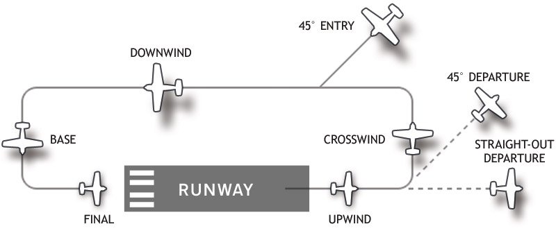
- Rectangular
- Comprises 5 legs - refer to this diagram: (altitudes as applicable for single-engine piston aircraft)
- Departure
- Maintain runway heading, continue to climb
- Typically turn onto crosswind leg at 700ft AGL
- Crosswind
- Continue climbing and level off at 1000ft AGL
- About 0.5-1 miles long
- Downwind
- Start slowing down, descending and configuring for landing once roughly abeam the landing point
- Run through landing checklist
- Base
- Steep, uncoordinated turns to final may result in a stall
- Final
- Stabilized approach
- All turns made to the left
- Flown at 1000ft AGL (above ground level) for single-engine piston aircraft
- Flown at 1500ft AGL for twin-engine and turbine-powered aircraft
- Flown at not more than 200kts
- But pilots should adjust speed to match other aircraft in the pattern
- In the case of a missed approach, initiate a go-around on the upwind leg, which is parallel to the runway and on the opposite side of the runway as the downwind leg.
- Report your position when turning onto each leg, but do not flood the frequency
Entering the pattern
- At towered airports, receive clearance to approach or depart.
- Tower may instruct an aircraft to enter the pattern at a particular point, or to make a straight-in approach
- At non-towered airports, it is the pilot's responsibility to abide by the rules and display common courtesy.
- Making straight-in approaches or entering the pattern at any point the pilot wishes may not be illegal, but it may not be the safest way.
- Observe other aircraft in the pattern and follow
- If no other traffic, over-fly the airport higher than traffic-pattern altitude to observe the windsock
- This determines which runway to use since planes always take-off and land into the wind
- Some airports also have indications near the windsocks or runways which direction the pattern is (left or right). The 'L' indicates which way to turn
- The pattern is usually entered 45 degrees to the downwind leg, at roughly abeam the halfway point of the runway, as such.
- Be vigilant and watch out for other traffic, especially since some aircraft do not have radios and may come unannounced for a straight-in landing.
- There are a few other methods of entering the pattern, but the bottom line is to use common sense, scan for traffic, and not to cross any of the traffic pattern legs at traffic pattern altitude.
Departing the pattern
- Either depart straight out (don't turn onto crosswind leg), or;
- Make a 45-degree turn in the direction of the cross-wind leg and leave the pattern after reaching the departure end of the runway, and traffic pattern altitude
Right of way
- An aircraft on final approach has priority over aircraft on the ground (ie. waiting for take-off) and aircraft in the air not on final approach
- If 2 aircraft are on final approach, the aircraft with the lower altitude has priority
- But continue to be vigilant, because the other pilots may not be following conventions, or may not have noticed you


Comments
Post a Comment